Sentinel-1 based InSAR assessment of the November 17th, 2015 Lefkada Earthquake
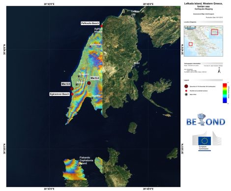
Operational capabilities developed in the context of BEYOND Center of Excellence project for EO based monitoring of natural disasters enable the rapid assessment of ground deformation field due to geophysical hazards, and the analysis of the hazardous event parameters. On 17th of November 2015, an earthquake of Mw 5.0 hit the western Greek island of Lefkada, located in Ionian Sea, an area that is well known for its active tectonics. A second stronger earthquake of Mw 6.4 successively followed inducing rock falls and landslides having as consequences two life losses and extensive damages to roads and buildings. Shortly after the events, BEYOND acquired a set of Sentinel-1 TOPSAR scenes, one before and one after the event. The images were combined to form an interferogram that depicts ground deformation due to the earthquake events. The fringes of the preliminary interferometric results, which are under further elaboration, reveal ground deformation of the order of ~20cm along the Line of Sight at the western part of Lefkada Island. As smaller deformation field is also apparent at the northern part of Cephalonia Island. The current seismicity at the Ionian Islands is an ongoing process, and BEYOND Center of Excellence is watching over the phenomenon using continuous acquisitions of satellite data. Further analysis and exploitation of very high spatial resolution satellite data such as CosmoSkyMed, TerraSAR-X and ALOS-PALSAR will be carried out in the next period towards detailed monitoring, mapping, and assessment of the phenomenon in collaboration with the European Space Agency through the CEOS DRM Seismic Pilot activation. New outcomes will be communicated in due time.
The BEYOND project Geo-hazard team.
More information is available on the project website: http://beyond-eocenter.eu/